Sunday, July 8, 2018

ITALIAN MASSAUA

Italian Massaua was the name used during the Italian colonization of Eritrea for the port-city of Massawa (2). From 1885 until 1947 the city was officially Italian ruled for more than sixty years,  evolving into a multinational trade city.

In 1941 nearly 40% of its inhabitants were Italians (or descendants of Italians), but after the 1960s they practically disappeared.

The former "Banco d'Italia" building in Italian Massaua, built in the 1920s (1)


History

At the end of the 19th century started the dominance of Europeans in the Eritrean region. The British -after the French occupied Djibouti- took over the control of this area with their Egyptian Protectorate, but requested the Italian military occupation of the city of Massawa in order to forestall the French expansion in the region.
On February 5, 1885 Massawa was occupied by 1500 Italian Bersaglieri (welcomed by the population and without fighting with the Egyptian troops) under the command of colonel Tancredi.(3)
Massawa, at the beginning of the Italian civil administration, was the capital of Italian Eritrea and the only urban center of the colony (http://www.ilcornodafrica.it/st-melecamassaua.pdf ). From February 1885 until 1897, Massawa served as the administrative center of the region, before Governor Ferdinando Martini moved his administration to Italian Asmara.(4) Between 1887 and 1932, the Italians expanded the Eritrean Railway, connecting Massawa with Asmara and then Bishia near the Sudan border (see www.trainweb.org/eritrean/scrapbook/when/running/italian_east_africa.html Eritrean Railways in "Guida dell'Africa Orientale Italiana) and completed the Asmara-Massawa Cableway.(5) At 75 km long, it was the longest ropeway conveyor in the world at the time.

The old Italian City Hall of Massaua


In 1890, Massaua had 5,000 inhabitants, of which almost 200 were Italians residents, with nearly one thousand of Italian military personnel. In the early 20th century, an architectural plan similar to the one in Asmara was adopted for city. It included a commercial and industrial area.(6)
The plan to improve the city that was prepared was aimed at reordering distinct parts that made up the town and that bordered the inlet of the port, the islands of Massawa and Taulud, connected to each other and the mainland by dams, the peninsulas of Gerar and Abd-el-Kader and the hinterland Edaga Berai near the dam Taulud. The "master" plan was prepared by the Italian Central Office of Civil Engineers in 1914, but was approved only for the part about the island of Taulud. The zoning required by the building code of 1915 fixed a structure which was confirmed by subsequent plans of the twenties and thirties.

The island of Massawa, where the ancient Ottoman-Arab core, unlike other urban colonial areas, had a mixed use for a variety of reasons, including a major that was linked to the use of the port, being the platform that limited its northern flank of the island the only one for the docking of large ships. So, in this area were concentrated all commercial activities. The island of Taulud, on whose northern end stood the palace of the "Khedive" Turkish, was reused first as the headquarters of the Italian military command, and then as the Government Palace: later became the area where was focused the Italian-Eritreans-metropolitan population. The area reserved to the natives was across the plain of Edgarà Berai, where arose the new suburbs after the Italian occupation. The peninsula of Gerar was given to the industrial area, while that of Abd-el-Kader remained occupied by military installations.
The works for the relocation of the port was started in 1913 on the basis of a draft by architect Luigi Luiggi and the Central Office of Civil Engineers of Massawa. In 1921 the city was badly damaged by an earthquake, but the reconstruction was done quickly through the grant of loans and government subsidies to individuals and businesses. In the same year were approved with a new plan where the building were programmed with earthquake standards.

Hotel Savoia, built in the 1930s

From 1928, with fascism rule were carried out in the port further expansion works, even in relation to the newly created railway and cableway to the capital Asmara. During the 1935/1936 war with Ethiopia in Massawa was recorded a significant increase in traffic, since it had become the main base for the supplies of the military campaign; and in subsequent years, with the new role of "Port of the Italian Empire", the city saw a great development with the increase of the population.

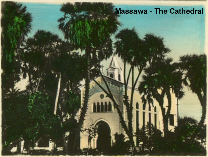
Italian Massaua in 1939 touched 16,000 inhabitants (of whom 6000 were Italians). Italians favored the development of Catholicism in the city, and the new catholic cathedral "Santa Maria" was built in the late 1930s.(7) In the same years was built also a modern Hospital, named Umberto I (https://www.ebay.co.uk/itm/Louis-naretti-No-2-photographs-Massawa-Eritrea-Hospital-Civil-Umberto-I-/362368942214 ).

The urban plans for the various areas of the city were implemented: in the island of Massawa was traced a road ring, while in that of Taulud was to be built a residential neighborhood. A settlement with industrial plants was expected in the peninsula of Gerar, with new areas to the decentralized Archico-Gurgussum. In addition it was decided the reorganization of the nearby villages of Edaga Berai and Amatereh with the small nucleus Otumlo located inside.

The Hotel Torino (built in 1938), an example of Venetian influenced architecture in Massawa

The main factory in Massaua was the "MASSAWA SALT PLANT": The society "Saline di Massawa" sprang up far away in 1905. In the 1930s it has undergone a radical transformation through the mechanization of all the installations. The production was sold inland - Eritrea and Ethiopia - and the remainder, made up of the production's main part, was exported. The principal countries to which the exports were directed were : Japan and Malaysia. Lately Kenia, Tanganika, Uganda and the Belgian Congo were added. A modern installation for purifying the salt was installed in the plant, capable of treating up to 1,000 tons daily. This salt, particularly pure and dry, was principally directed towards the japanese industries.  For the forwarding of the salt destined to the export the Society used an own dock where ships of tonnage up to 13,000/14,000 tons could moor. A complete plant of conveying belts, which allows a loading speed in excess of 500 tons per hour was installed on this dock. The salt directed inland was sacked into bags which were directly manufactured in a suitable section of the establishment itself. Inland forwarding was mainly done by railway, and in the huge establishment there was a rational railway link. The average number of the workers was of 280/300 units. During the crop' season they increased to over 400. Among the latest accomplishments in 1940 it needs to be evidenced a complete Chemical Laboratory for the daily control of both the common and the purified salt.

Another big factory was the S.A.G.E. (SOC. AN. GHIACCIAIE ERITREE) :  It was the best equipped ice factory of Eritrea with dozen of employees. Additionally, in Massaua there were minor construction, mechanical, electrical, etc..companies (http://researchomnia.blogspot.com/2015/04/italian-eritrea-industries.html#comment-form)

The most important cinema/theater was the "Impero", also called 'Corso': in 1940 the city enjoyed the typical Italian lifestyle with restaurants and cafes within some strolling "lungomare" areas.

In Massaua there were 3 cinemas in early 1940, just before the start of the war:

1) Cinema Corso (850 seats)

2) Cinema Eritrea (700 seats)

3) Cinema Italia (500 seats)


In the port area was planned the construction of a huge "Stazione marittima" (Sea Station) for ocean liners.

This maritime station was going to be connected to the enlarged and improved railway station of Massaua.

But also to the projected railway line toward Mersa -with the decauville of the "potash line" to Adaito- and toward Assab (see map to the right showing in black the potash line Mersa Fatuma-Colulli/Adaito south of Massaua).

But the beginning of WWII blocked all this further improvements of Italian Massaua.


The Port of Massaua

At the end of the 19th century, the Kingdom of Italy created a modern port in Massaua for their newly acquired colony of Eritrea.(8)


The Massaua Station on the Eritrean railway.

The Italian colony suffered repeated earthquakes. Most of the city was completely destroyed by the 1921 Earthquake

It took until 1928 to fully restore the port,(9)hampering initially the Italian colonial ambitions.


The Italian colonialists had nevertheless built Italian Massaua to become the largest and safest port on the east coast of Africa, and the largest deep-water port on the Red Sea. Between 1887 and 1932, they expanded the Eritrean Railway, connecting the port of Massawa with the Eritrean capital Asmara, and completed the 75 kms long Asmara-Massawa Cableway.(10) As a consequence the commercial activity of the port grew to nearly one million tons of merchandise, with more than 180000 passengers in 1939.(11)

In early 1941, Italian Massaua had nearly 20,000 inhabitants, of which almost 7,500 were Italians and descendants of Italian soldiers & native girls (because of the so called "madamato").
After the creation of the Africa Orientale Italiana the Italian government increased the international ship lines serving the port of Massaua: while in the late 1920s were needed 16 days from Massaua to Genova or Venice in Italy, after 1939 were needed only 5 days.


Ocean liner "Conte Biancamano" connected Massaua with Italy and China/Japan.


List of main ship routes from Italian
Massaua in early 1940, just before the start of war against the Allies:(12)
  • Italia-Massaua-China/Japan (Italian Line), biweekly
  • Genova-Massaua-Mogadiscio-Chisimaio (Lloyd Triestino), weekly
  • Italia-Massaua-Australia (Lloyd Triestino), weekly
  • Napoli-Massaua-Assab-Gibuti (LLoyd Triestino), weekly
  • Italia-Massaua-Assab-South Africa (Lloyd Triestino), monthly
  • Venezia-Massaua-India (Veneta di navigazione), weekly
  • Genova-Massaua-Mogadiscio (RAMB), weekly
  • Venezia-Massaua-Mogadiscio (RAMB), biweekly
  • Genova-Massaua-Assab (I. Messina), biweekly
The service was done with modern Ocean liners like the "Conte Biancamano", "Vulcania", "Victoria", "Esquilino" and "Viminale".
In those years there was even a local service (called "linea Circolare del Mar Rosso") that connected all the main ports in the Red Sea. Another (called "linea Intercoloniale") connected Massaua with Assab-Gibuti and the main ports of British Somaliland and Italian Somaliland.

The port of Massaua was going to be enlarged in 1941, but WWII blocked it.

Italy was one of the Axis powers during World War II and Massawa was the homeport for the Red Sea Flotilla of the Italian Royal Navy.By June 1940, when the anticipated war with the British Empire finally began, the port of Massaua was the only base along the lengthy coastline of Somalia and Eritrea with a strong naval presence. 

At this Red Sea port, Italy deployed eight modern submarines, seven destroyers, two old torpedo boats, five World War I-era motor torpedo boats, and the large colonial sloop, Eritrea. This was hardly the oceanic strike force Italy’s maritime strategists envisioned, but Great Britain nonetheless regarded these ships as a knife pressed against the throat of Suez (however, the Red Sea Squadron’s inadequate stocks of fuel and ammunition limited its role to one of survival and sea denial for the duration of what the Italian government hoped would be a short war).

Sunken ships in 1941 Massaua port
On April 8, 1941 one motor-torpedo boat of the Flotilla, the MAS 213, made a successful torpedo attack on the british cruiser HMS Capetown partially sinking it just out of the Massaua port.(13)

When the city fell during the East African Campaign, a large number of Italian and German ships were sunk in an attempt to block use of Massawa's harbor.(http://warfarehistorynetwork.com/daily/wwii/red-sea-naval-war/ ).

Indeed as the British advanced toward Eritrea during their East African Campaign in World War II, Mario Bonetti—the Italian commander of the Red Sea Flotilla—realized that the enemy would overrun his harbor. In the first week of April 1941, he began to destroy the harbor's facilities and ruin its usefulness to the British. Bonetti ordered the sinking of two large floating dry docks and supervised the calculated scuttling of eighteen large commercial ships in the mouths of the north Naval Harbor, the central Commercial Harbor and the main South Harbor. This blocked navigation in and out. He also had a large floating crane scuttled. These actions rendered the harbor useless by 8 April 1941, when Bonetti surrendered it to the British. Scuttled ships included the German steamers Liebenfels, Frauenfels, Lichtenfels, Crefeld, Gera and Oliva. Also scuttled were the Italian steamers Adua, Brenta, Arabia, Romolo Gessi, Vesuvio, XXIII Marzo, Antonia C., Riva Ligure, Clelia Campenella, Prometeo and the Italian tanker Giove. The largest scuttled vessel was the 11,760-ton Colombo, an Italian steamer.
The most dangerous problems for salvage were Brenta, which contained a booby trap sunk in one hold made of an armed naval mine sitting on three torpedo warheads, and Regia Marina minelayer Ostia, which had been sunk by the British airplanes with several of its mines still racked. Thirteen additional coastal steamers and small naval vessels were scuttled as well.
From 15 April 1942, later master diver and salvage specialist RNR Lieutenant Peter Keeble (then a complete rookie in both disciplines) was assigned to the clearing of the harbour.(14) He succeeded only in the simple task of salvaging an ex-Italian tugboat. The same month, United States Navy Commander Edward Ellsberg and his handful of crew arrived to take over. The wrecks were salvaged in short order and the port was returned to service, as part of what had now become the British protectorate of Eritrea.

In 1945, following the end of World War II, the port of Massawa suffered damage as the occupying British either dismantled or destroyed much of the facilities. These actions were protested by Sylvia Pankhurst in her book Eritrea on the Eve.(15)


Massaua in 1888, when just occupied by the Italian Bersaglieri


Notes

  1.  Banco d'Italia in Massaua being rebuilt
  2.  Map of Italian Massaua (1929)
  3.  "Occupazione di Massaua" (in Italian)
  4. Belula Tecle-Misghina. Asmara - an urban history. Edizioni Nuova Cultura, 2015. ISBN 8868123541. 
  5.  Giovanni Gentile, Calogero Tumminelli. Enciclopedia italiana di scienze, lettere ed arti, Volume 1. Istituto Giovanni Treccani, 1929. p. 66. 
  6.  Italian Massaua Plan (in Italian). p. 65
  7.  Massaua Cathedral
  8.  Images of Italian Massaua before WWI
  9.  Killion, Tom (1998). Historical Dictionary of Eritrea. The Scarecrow Press. ISBN 0-8108-3437-5. 
  10.  "La Teleferica Massaua-Asmara" cableway brochure, translated by Mike Metras, Dave Engstrom, and Renato Guadino
  11.  GuglielmoEvangelista. "Porti dell'Eritrea" ([1])
  12.  "Porti dell'Eritrea", by Guglielmo Evangelista
  13.  MAS 213 attack on British cruiser (in Italian)
  14.  Keeble, Peter (1957). Ordeal by water. Longmans, Green & co. No ISBN number available.
  15.  Also detailed in the chapter "The Feminist Fuzzy-Wuzzy" of Michela Wong's I didn't do it for you: how the world betrayed a small African nation (New York: Harper-Perennial, 2005), pp. 116-150.

Bibliography 

  • Mantegazza, Vico. Da Massaua a Saati: narrazione della spedizione italiana del 1888 in Abissinia. Editore F. Treves, 1888. (University of Chicago, 2014 [2])
  • Maravigna, Pietro. Come abbiamo perduto la guerra in Africa. Le nostre prime colonie in Africa. Il conflitto mondiale e le operazioni in Africa Orientale e in Libia. Testimonianze e ricordi. Tipografia L'Airone. Roma, 1949.
  • Negash, Tekeste. Italian colonialism in Eritrea 1882-1941 (Politics, Praxis and Impact). Uppsala University. Uppsala, 1987. 
  • US Navy Commander Edward Ellsberg. Under the Red Sea Sun, (1946). Dodd, Mead and Co., New York

Tuesday, June 5, 2018

ITALIANISED CITIES OF BENADIR

Italy started  to have colonies in the Horn of Africa at the end of the 1800s. One of the first colonizations done after Italian Unification was in the coast of Somalia called "Benadir". In a few decades thousands of Italian colonists settled in the cities of Benadir, mainly in the Somalian capital Mogadiscio, starting  the "colonial italianisation" of the region. In half a century (from 1890 to early 1941, when they lost control of their Somalia because of WW2) the Italians transformed a region that was with a medieval society based on slavery to a modern region (one of the best in all Africa) with airports, ports, railways, roads, hospitals, schools, radio-telegraph installations, dams and with a growing economy based on the export of bananas/cotton (and salt) to the world.

BRIEF HISTORY


Indeed in the coastal ports of Benadir settled the first Italian colonists in Somalia: Mogadiscio, Merca, Brava and Chisimaio (these were the names in Italian language) were developed since the early 1900. In the following decades the colony grew, experiencing a huge development. The best indication of this achievement can be surmised by the resumen of the main school & social institutions (from newspapers to cinemas & sport/cultural associations) that existed in "Mogadiscio italiana" and Benadir in 1939:  


Map of Benadir (dark green color) : The Benadir ports management, initially done by the "Compagnia Filonardi" (1893-96) and later by the "Società Anonima Commerciale Italiana del Benadir" (1899-1905) was finally taken by the Italian government that obtained the control of the entire region of Benadir through an agreement with the British government and the payment of 144,000 British Sterlings to the Zanzibar sultane (London treaty, January 1905).


Indeed
there were Italian colonists also in Itala (now Adale) in northern Benadir and in the Shebelle rider valley's Villaggio Duca degli Abruzzi/Villabruzzi (now Jowhar), Genale (now Janale) and  Vittorio di Africa/Vittorio  (now Scialambod). In the interior of Benadir some Italian merchants settled in Baidora (now Baydhabo), just before the creation of "Italian Somalia" in 1905.

The Italians -settling in huge numbers- italianised the capital Mogadiscio (that in 1940 was called the "White Pearl of Indian Ocean" and was practically a fully Italianised city with over 40% of inhabitants being Italians or descendants of italians) and the 3 main cities in the Shebelle river farm area (Villabruzzi with 3000 colonists, Genale  with 700 and Vittorio with 400). 

But little communities of Italian colonists existed also in the Benadir cities of Merca (250 Italians), Brava (150), Chisimaio (120), Baidoa (300) and Itala (50), where they lived in small areas that were the only fully modern & developed sections of these little cities. Outside of the Benadir region there were some small communities of Italian settlers in a few cities, like in Dante (500 italians) now called Hafun.


ITALIANISED CITIES


The initial phase of colonialism done by the newly created "Kingdom of Italy" in the last decades of the XIX century were full of difficulties. Italy had no experience like the French and British colonial powers and the first steps were not easy to do, as happened in the Benadir region around Mogadishu. The five ports of Benadir (Chisimaio/Kismayu, Brava/Baraawe, Merca/Marka, Mogadiscio/Mogadishu & Uersheik/Warsheik) were initially controlled by an Italian private company: the "Filonardi compagnia" (later called  "Benadir company").


Only in 1905, the Benadir Company's concession was revoked and for the first time the Italian government took direct control over the Benadir and created the colony of "Somalia" (with the surrounding territories, later incorporated with treaties & pacification of the Somalian clans/tribes).

In the following nearly 40 years the Italians settled in large numbers in their "Italian Somalia" until their defeat during WW2.  They started a process of "Italianisation" of the main cities of Benadir, with architectural and socio-economical consequences. It is noteworthy to pinpoint that in 1939 Italian Somalia nearly all the development was concentrated in the triangle "Genale-Villabruzzi-Mogadiscio" of Benadir, where most of these colonists (Italians and their descendants, with some thousands born from Italians mixed with Somalians) were resident.

The following are excerpts about the Italianised cities of Benadir: Mogadiscio, Villabruzzi, Genale and  Vittorio. Additionally there are excerpts about the small Italian presence in Merca, Brava, Chisimaio, Baidora, Itala (and -with little data- Dante, a city outside of Benadir).


MO G A D I S C I O

(for a complete information- read my https://dadfeatured.blogspot.com/2018/05/italian-mogadishu.html


Thousands of Italians settled in Mogadishu and created from scratch a vibrant economy. They also founded in this metropolitan area some small manufacturing companies in the forty years from 1890 to 1941.

Furthermore they developed many agricultural areas in the territories south & north near the Somalia's capital. 

in the early 1930s, new buildings and avenues were buit in the growing capital of Italian Somalia. A 114 km (71 mi) railway was laid from Mogadishu to Villabruzzi (Jowhar), that was extended until Buloburde in 1935 withy a "decauville" railway. And an asphalted road, the "strada Imperiale", was also constructed and intended to link Mogadishu to Addis Abeba in Italian Ethiopia. In the late 1930s an airport and an enlarged port were added to the called "Mogadiscio imperiale" . 

Mogadiscio in 1940 was planned to be linked to Addis Abeba by railway and to Djibouti/Eritrea by an asphalted coastal road (similar to the "via Balbia" in coastal Libya), but WW2 blocked all these projects. In 1940, the Italo-somalian population numbered 22000, accounting for over 44% of the city's population of more than 50000 residents (http://www.fedoa.unina.it/1881/1/Santoianni_Progettazione_Architettonica.pdf)
and making the city the second most "citta' italiana" in the Horn of Africa (with many cinemas and cafes in the typical "Italian style" way of life).

In early 1941 in Mogadiscio there were the following learning institutions:
* Schools for Italians:
**Scuola elementare mista • Ginnasio-Liceo Emilio De Bono
**Missione cattolica dei Cappuccini
**Asilo d’infanzia e scuola elementare parificata mista Regina Elena
* Schools for Native Somalis:
**Missione cattolica orfanotrofio Guido ed Elisa Corni e scuola parificata

**Scuola speciale per i figli dei notabili somali
In 1938 was opened in Italian Mogadiscio the first "Library" of Somalia, with public service to Italians and native Somalis

Mogadishu remained the capital of Italian Somaliland throughout the latter polity's existence. During WW2 it was captured by British forces in late February 1941 and since then the number of Italians started to diminish until their nearly complete disappearance in the 1990s.

V I L L A B R U Z Z I
Villabruzzi was the name commonly used for actual Jowhar in Italian Somalia (http://xoomer.alice.it/fernandotermentini/somalia.htm ).

Photo of the local Hotel 

The village was founded by the Duca degli Abruzzi (a noble, parent of the King of Italy) with the name "Villaggio Duca degli Abruzzi" in 1920. It was an agricultural settlement, experimenting with new cultivation techniques. In 1926, the colony comprised 16 villages, with some 3,000 native Somalians and more than 300 Italian colonists inhabitants.
From 1911 in the Shebeli river area the Italian government started to take the local farmers and resettle them in specific new villages in an attempt to improve the economy of Italian Somalia. The area around the "Villaggio Duca degli Abruzzi" was the most agriculturally developed of Somalia before WW2 and had some food industries.
Villabruzzi grew mainly after the creation of the SAIS (a huge farm production company) and the construction of the railway connecting it to Italian Mogadishu: the 114 kms of the railways allowed easy exportation to the Port of Mogadiscio of the huge  production (https://farofrancescocrispicapeguardafui.wordpress.com/2016/04/22/le-ferrovie-della-somalia-italiana/ ).

Indeed in the area of the agricultural settlement SAIS there were 45 kms of small railway "decauville" to move the products and nearly 100 kms of internal asphalted roads.
 The company SAIS ("Societa Agricola Italo-Somala") was founded in Milan by the Duca d'Abruzzi in November 1920 with a capital of 24 million pounds of the time. A great facility, the only one in East Africa, equipped with modern machinery and able to work about 3,000 tons of sugarcane per day. Next to the sugar mill, he created in Villabruzzi a distillery and a chemical laboratory for analysis of the sugarcane and for the control of the products during the processing phase. The main machines were powered by the combustion of natural gas obtained from the fermentation of waste from sugar cane and cereals processed. Fernando Termentini in "Somalia, una nazione che non esiste"
In 1940, the "Villaggio Duca degli Abruzzi" (actually known as "Jowhar") already had a population of 12,000, of whom nearly 3,000 were Italian colonists, and enjoyed a notable level of development also as a small manufacturing area.


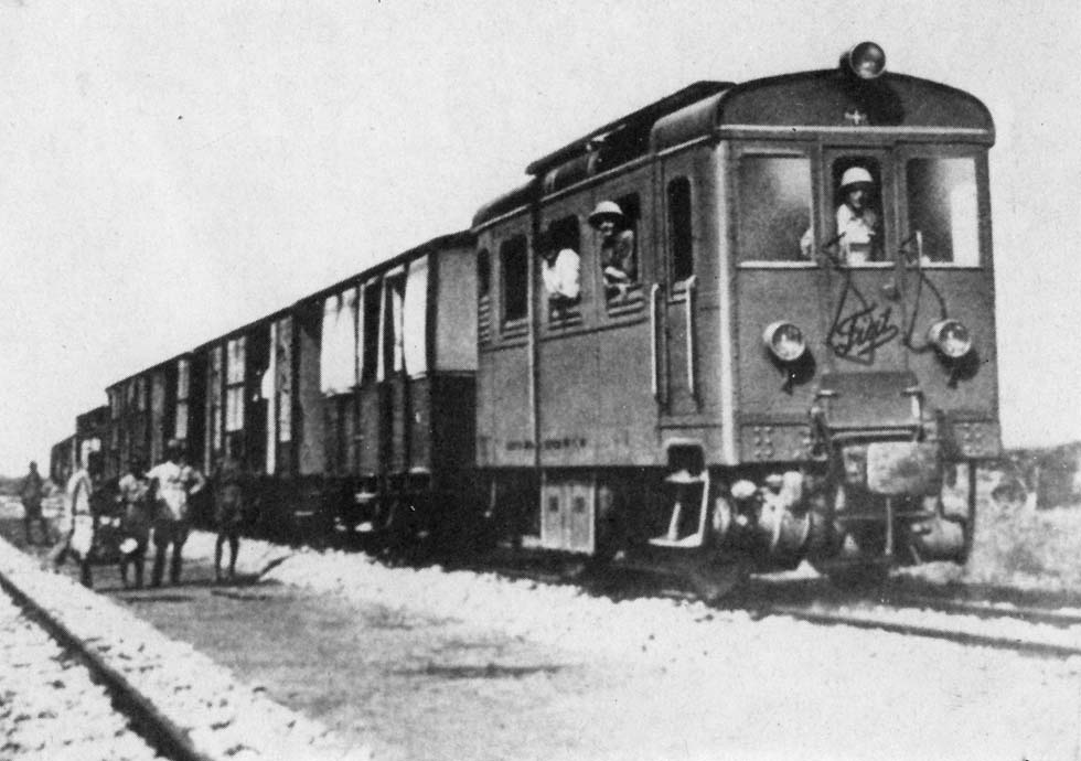
Train in Somalia before WW2 with TL150 Fiat engine. 
The Italians, who believed in the economic potential of the region, also built a railway system that linked Jowhar/Villabruzzi to the capital for the next thirty years, and was used mainly to export bananas and coffee to Europe


It is noteworthy to pinpoint that nearly all the development in Italian Somalia was in the triangle "Villabruzzi-Genale-Mogadiscio".  

This triangle area was one of the most developed in sub-Saharan Africa. The sanitary conditions in this area were improved to European standards with new hospitals and sanitary facilities.(https://books.google.com/books?id=XVgrDwAAQBAJ&pg=PT116&lpg=PT116&dq=genale+italian+somalia&source=bl&ots=sF2iJfwfmB&sig=m7MD2cx4aiVve4sswzKdTp8a4A8&hl=en&sa=X&ved=0ahUKEwiFop7fusrbAhVMgK0KHeTxDaQ4ChDoAQg3MAM#v=onepage&q=genale%20italian%20somalia&f=false)


The Italians in this triangle created the first children parks and nurseries, establishing the first fight against analphabetism in Somalia with the compulsory rule to go to the first years of elementary schools for all native children. When the British conquered Villabruzzi in early 1941 they made a report pinpointing that between the native population the analphabetism was reduced to only the old generations (something unique in all eastern & central Africa).


In early 1941 in Villabruzzi there were the following instructional institutions:
* Schools:
**Missione Cattolica dei Cappuccini
**Scuola Missione Cattolica (Scuola elementare mista)


At independence, the vacuum created by the outgoing Italians was not filled by the new Somali elites in charge, as the latter deemed the cattle trade and urban assets more profitable.

G E N A L E

Genale was a village created by governor De Vecchi after WW1 for Italian colonists & their workers, in the place where the Shebelle river is nearest to Merca and the Indian Ocean.


Map of the "Concessioni Agricole" (in green color) around Genale and Vittorio d'Africa

Genale grew around the creation of the Shebelle river dam (one of the biggest in the 1930s Africa), that allowed the creation of "Concessioni Agricole" (farm ranchs) for agricultural development: they were so successful that soon started to appear the problem of lack of native workers, because the Italians in 1905 ordered the elimination of slavery and many of them moved away from the area.  Consequently De Vecchi ordered a conscription service for workers in the Benadir, because the native did not want to cultivate the land. But soon the somalian people started to improve their socio-economic situations with their new jobs: the economy flourished with a growing exportation of products (cotton, bananas, etc..).


"....Genale was created in 1924 by a group of settlers from the Italian city of Torino, with the supervision of the Italian governor of the colony. Near the Genale of the colonists and separated by the Shebelle river, soon grew a bigger city populated by Somalis (working as cheap labor force in the plantations): the actual Janaale. After WW2 remained only Janaale, while Genale disappeared when the defeated Italians moved away from Somalia.In 1924 indeed it was started the Italian colonization of the area of Genale, in southern Somalia, forming a group of small and medium-sized farms. Most settlers consisted of old fascist militants of Turin who had followed in this Italian colony the new governor of Somalia, Cesare Maria De Vecchi. The first informal association between farmers, however, arose only in 1928 (http://www.ilcornodafrica.it/rds-01emigrazione.pdf ).The main crop of the area was cotton and was done by small farms owned by those Italian settlers: about one hundred with an area varying between 75 and 600 hectares (with an average that oscillated about 200) with a total area of about 20,000 hectares.  At least until 1931 the cotton was the main crop, later replaced by the banana production (http://images.delcampe.com/img_large/auction/000/147/765/556_001.jpg?v=4 ), whose harvest was sold to the Italian State, that did the marketing in Italy as a monopoly. During the Italian colonial period Genale was the center of a vast area of agricultural concessions of 20,000 hectares for the cultivation of banana, cotton and other subsidiaries. The bananas were marketed by the Royal Company Monopoly Bananas (abbreviated RAMB) that had, in fact, a monopoly of the export to Italy granted in order to safeguard banana production in Somalia on the Italian market. Consequently, until the 1950s nearly all the bananas consumed in Italy came from the Genale area…" Bruno D'Ambrosio (Universita' di Genova)


In early 1941 in Genale (Caitoi section)  there were the following instructional institutions:
* Schools:


**Scuola Missione Cattolica (Scuola elementare mista)

 In the Italian Genale there were in 1940 nearly 700 Italian colonists, but after WW2 nearly all of them moved away and since the 1980s no one has remained. The city actually has 8000 inhabitants (of whom nearly one thousand are descendants from Italians and Somalian girls) and is predominantly inhabited by people from the Somali ethnic group, with the HawiyeHiraab Clan well represented.


Villas planned for Italian colonists in Genale in 1933, with similar design to the one of "Villa Somalia" in Mogadiscio.

V I T T O R I O


Vittorio di Africa (originally called "Vittorio d'Affrica" or simply "Vittorio") was a small town in southern Italian Somalia, created by Italian colonists in the late 1920s near the southern Shebelle river.

Vittorio  -named in honor of the king of Italy Vittorio Emanuele II- was located halfway between the Governmental Company of Genale and the port of Merca, to which it was joined by an asphalted road  above the dunes and a railway decauville, and connected thanks to a dense network road with all private companies. 

It was founded by the Prince Umberto di Savoia on march 5, 1928. He laid the foundation stone of all the main buildings: the residence, the church, the school, the hospital and the Zaptiè barracks. 


The main production of Vittorio farms was since 1928 cotton and later -in the late 1930s- bananas. 

Initially it was important the production of cotton: in the small city there was also a manufacturing company for cotton, as shown in the above photo, with a cotton ginning building for the Italian  cotton industry. 


Indeed in 1928 one hundred Italian colonists (mostly were fascists from the Torino area) created in the south of the Genale concessions (called in Italian Concessioni agricole) this small city actually called "Shalamboot", that had in 1940 a population of nearly 1200 inhabitants (of whom 400 Italians and descendants of Italians & native girls). 

It was located 11 kms from Merca and its port. In Vittorio was located the main building/headquarters of the "Consorzio Agrario".

During the Italian colonial period Genale and Vittorio di Africa were the center of a vast area of agricultural concessions for the cultivation of banana, cotton and other subsidiaries. The bananas were the main product and were marketed by the "Royal Company Monopoly Bananas" (abbreviated RAMB) that had, in fact, a monopoly of the export to Italy granted in order to safeguard banana production in Somalia on the Italian market. Consequently, until the 1950s all the bananas consumed in Italy came from the area of Genale and Vittorio.


LITTLE ITALIAN PRESENCE

M E R C A

Nearly 250 Italians were resident in Merca in 1940. It had small factories including a plant for packing and shipping of bananas.
 
Merca is a port city, but also an industrial city with its 100 oil mills, with its small textile industries for the manufacture of multicolored cotton fabrics and small sites for the construction of fishing boats.

The Port of Merca was the second in Italian Somalia after the capital and was nicknamed "port of bananas" (porto bananiero) because from there was exported in those years the huge production of Somali bananas toward Italy.

In the city of Merca there was a huge economical development in the 1930s, due mainly to the growing commerce of the port of Merca connected by small railway to the farm area of Genale.


In 1912 was created outside Merca the famous "Istituto Siero-vaccinogeno" in order to improve the livestock of Somalia: it was greatly appreciated by the local natives who practiced animal husbandry. 


In Merca there was a "Missione Cattolica" and a  "Scuola Missione Cattolica" (parificata). 


Actually there it is still standing an "Obelisk" inside Merca, created by the Italians in 1936.


B R A V A


Brava (actual Barawa) was an important port in the southern Shebelle river area. A few dozen Italians settled in the city in the first years of the existence of the colony of Somalia.


In 1903, according to a census of the Italian journalist and anti-slavery activist Luigi Robecchi-Brichetti of the 3000 inhabitants of Brava 830 were slaves. The first thing the Italians did when took control of the port city in 1905 was to abolish the slavery, with the help of catholic missionaries.  


In 1940 there were nearly 150 Italian colonists resident in the city, that was improving from the production & export of cotton in the surrounding area.In Brava there was a "Missione Cattolica" and a "Scuola Missione Cattolica" (parificata). 


C H I S I M A I O


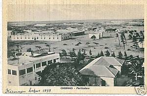
Chisimaio was the third most important city in Italian Somalia. In 1925, when Italy took possession of what was British Kysmayo,  there was a very small group of Italian settlers, mostly merchants, living in the city. 

In 1940 there were in Chisimaio more than one hundred Italians, most of them working in the export of cotton and bananas. In Chisimaio there was a "Missione Cattolica" and a  "Scuola Missione Cattolica" (parificata). 


In 1930 the Italian governor Guido Corni created in Chisimaio, by the company specialized in accumulators of Dr. Scaini -based in Milano- the first wind farm in the Italian colonies and one of the first in all the world (as can be seen in the following photo ). 


The  aeroelectric plant produced 2/3 of the electricity needed by the city.


B A I D O R A


The small city -called also "Baidoa"- was the residence of the Governor of Upper Juba in 1940, on which a fertile and luxuriant region depends, so much so as to be called the "Switzerland of Somalia". Baidora was organized and urbanized to the best with a restaurant, a radio & telegraph station, the post office, an infirmary with doctor and pharmacy. The Italian colonists were nearly 300.


.

In Baidora there was a "Missione Cattolica dei Cappuccini " (with elementary school for Italians) and a  "Scuola Missione Cattolica" (for native and Italians). 

I T A L A

During the colonial period before the official creation of "Italian Somalia", the city of Adale was renamed "Itala" and chosen by Vincenzo Filonardi as the headquarters of his newly created colonial possessions. 

After 1905 remained as a small government center until 1941, with only a few dozen Italian colonists resident. 


In Itala there was an important radio & telegraph station for communications with Addis Abeba and Italy.


scuole per italiani
OUTSIDE BENADIR

There were also some Italians living in Somalia outside the Benadir region. The most important little community was in Dante (now Haifun), but there were a few also in Obbia (now Hobyo)  and Rocca Littorio (now Galkayo).

D A N T E

Outside of Benadir the Italian colonists settled in a few localities. The most important was Dante (now called Hafun) in northern Somalia. Here in 1930, an Italian firm invested capital to exploit salt deposits. 


• Scuola elementare mista   • Ginnasio-liceo Emilio De Bono

• Missione cattolica dei cappuccino Missione cattolica orfanotrofio Guido ed Elisa Corni e scuola parificata Scuola speciale per i figli dei notabili somali.
                             Istituzioni
Casa del fascio. Opera nazionale dopolavoro. Museo della Garesa. Laboratorio chimico-batteriologico. Regio automobile club d Italia. Consociazione turistica italiana. Compagnia italiana Turismo. Circolo duchessa d Aosta. Circolo del tennis. Associazione motociclistica Mogadiscio. Associazione sportiva Mogadiscio. Unione sportiva Mogadiscio. Istituto Luce.«Somalia Fascista» (newspaper of Federazione dei Fasci di combattimento) «Somalia Sportiva» (magazine of Federazione dei Fasci di combattimento) «Somalia Cristiana» (magazine of Vicariato Apostolico) editori: Stamperia del governo. Cinema Impero. Supercinema. Cinema Italia

The "Hafun Salt Factory" was created and was the main producing facility of sea salt on the world in the 1930s. By 1933-34, the Hafun salt works were producing more than 200,000 metric tons of salt, most of which was exported to the Far East. It was the second most important export product from Somalia, after the bananas.

. Asilo d’infanzia e scuola elemen-


Nearly 500 Italians worked in the salt facilities in 1940, that had also a small decauville railway (see bottom photo).  In Dante there was a "Missione cattolica dei Cappuccini" (with a "Scuola elementare parificata" for Italians) and a "Scuola Missione Cattolica" (for native & Italians). 
tare parificata mistaRegina Elena.

scuole per africani


Map of Somalia Governorate (1936-1941). On the map can be seen the location of the italianised cities of Benadir within the enlarged borders of "Somalia Italiana", that included the Ogaden region since the 1935/1936 Ethiopia conquest.